Geospatial Framework Data for Virginia & Beyond
- USGS EarthExplorer provides 1-stop shopping for U.S. and world-wide imagery (aircraft & satellite) and other data products, including contours, topos, DEM’s, lidar, etc. EarthExplorer is generally appropriate for downloading data by tiles.
- USGS LCMAP Are you searching for land cover and land cover change data for a user-defined region? Then look no further. The LCMap View provides efficient data download options for regional / statewide datasets.
- USGS National Map provides access to several data products, including lidar.
- NRCS Soils Data
- Farm Service Agency (FSA) National Aerial Imagery Program (NAIP) for Virginia (and beyond):
NAIP is a program designed to acquire peak growing season “leaf on” imagery, and deliver this imagery to USDA County Service Centers, in order to maintain the common land unit (CLU) boundaries and assist with farm programs. The goal of NAIP is to collect 1 meter imagery for the entire conterminous United States. The imagery is either natural color or “four band” imagery and is delivered in the year of acquisition. NAIP imagery can be accessed through ArcGIS Services. - USGS Global Visualization Viewer (GloVis) provides access to several imagery platforms including Landsat, Sentinel, and Aster.
- GoogleEarth Engine Is it a cloud-based data analysis tool or a catalog of satellite imagery and geospatial datasets? It is both software and data (and more…). If GE Engine is the right fit for you, then you’ll need to check out the GE Engine Tutorials as well.
- USDA Geospatial Data Gateway allows you to select various datasets by county.
- The Virginia Geographic Information Network (VGIN) Division of the 9-1-1 and Geospatial Services Bureau (NGS) provides framework data and other basemap data assets through the Virginia Base Mapping Program. Questions about VBMP data products should be directed to VGIN staff. In addition to developing statewide standards and supporting the development of the VBMP, VGIN also maintains a Geospatial Data Clearinghouse.
- Stream data & connect via VGIN’s ArcGIS server: https://vginmaps.vdem.virginia.gov/arcgis/rest (with additional documentation provided here).
- Virginia Tech (through eGIS) also provides data streaming services (mirrowed site). More info. here: https://garden.gis.vt.edu/
- VGIN downloads for most recent imagery and DEM’s: https://experience.arcgis.com/experience/3876523cde9a434197579e995a92d94c
- VGIN request older imagery, TIFF’s, and DEM’s: https://experience.arcgis.com/experience/2bb22b3b42824c1daae6ed5b2427f80b
- VBMP framework data layers includes the Virginia High Resolution Ortho Photography program, as well as other downloadable or streamable datasets.
- Open Topography provides access to lidar and other topographic data products from around the world, including the U.S. Geological Survey’s (USGS) 3D Elevation Program (3DEP)
- Check out Virginia Tech Library’s Geospatial Data Discovery Site or the University of Virginia’s Spatial Tech Scholars Lab.
- Search for geospatial data via ArcGIS Online
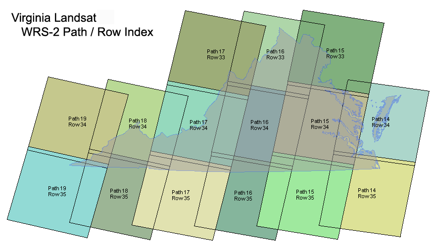
Virginia Landsat Path/Row index
Did you know that it would take a mosaic of 15 Landsat tiles to cover the state? How lucky we are!

