The Digital Atlas of Virginia was developed in response to continued teacher demands for accessible map based teaching resources, and is a direct result of meetings with the Virginia Department of Education, and with individual educators. Maps included in the initial release of the Digital Atlas were identified by a focus group of educators as being critical resources to support classroom instruction. As a result, many of the maps and resources contained in the digital at last directly support Virginia’s Standards of Learning (SOL’s)!
The Atlas includes the following maps:
Aerial Photography of the Williamsburg and Jamestown Area (11 mb)
Annual Average Wind Resource Potential of the Mid-Atlantic United States at a 50 Meter Height (770 KB)
Aquifers in and Around Virginia (11 MB)
Boundaries of Landsat Scenes (150 KB)
Change in Night-time Lights: 1992-2000 (1.5 MB)
Coal Fields Around Virginia (500 kb)
Current and Historic Locations of Virginia’s Capital (150 KB)
Day and Night Land Surface Temperature (8 day average) from the MODIS Sensor (1.7 MB) – To allow students investigate the effects of urban areas on the surface temperature (urban heat island effect).
Difference Between Annual Solar Resources for Flat Plate Collectors and Concentrated Systems (500 KB) – Allows students to investigate the differences in annual solar resources throughout the US and which type of solar collection system is more appropriate
Earthquakes in Virginia between 1774 and 2003
EcoRegions of Virginia (5MB)
Elevation of Virginia from the Shuttle Radar Topography Mission (SRTM) (2 MB)
Forest Cover of Virginia in 2000 (300 KB)
Image Comparison of UVA in Charlottesville (4.5 MB)
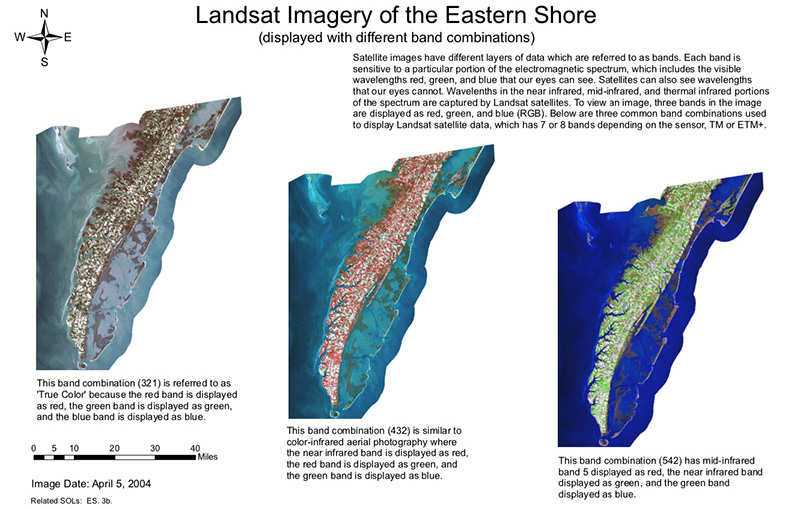
Landsat Imagery of the Eastern Shore (displayed with different band combinations) (7 MB)
Lights at Night in Virginia (1 MB)
Per Capital Income by Census Tract (900 KB)
Physiographic Provinces of Virginia (5 MB)
Satellite Imagery of the Williamsburg and Jamestown Area (321, 432, 542, 742 band combinations):
- Band Combinations 321 (680 KB)
- Band Combinations 432 (700 KB)
- Band Combinations 542 (740 KB)
Soil Available Water Capacity in Virginia (1.6 MB)
Strip Mining in Wise County (26 MB)
The Eastern Shore shown by 15 meter ASTER (13 MB)
Virginia in the Continental United States (17.5 MB)
Virginia in the World (9 MB)

